Assignment:
From each map, what can you tell us about the land and country’s place/position on the continent? If it is an island, what continent do the people affiliate with culturally and economically? Why?
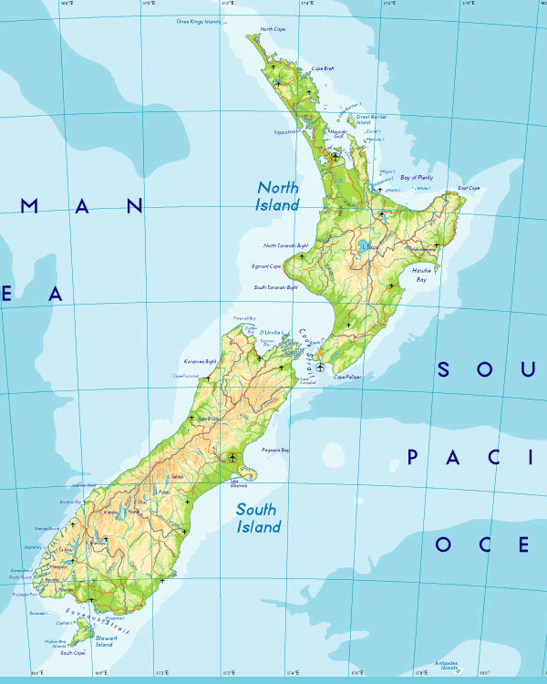
New Zealand is made up of two main islands, the North Island and the South Island, and is separated by the Cook Strait and also of many other smaller islands. The area of the two islands is comparable to Colorado. The North Island is about 515 mi long and has volcanic action in its south-central part. The South Island has the Southern Alps along its west coast, with Mount Cook being 12,316 ft making it the highest point. Its capital is Wellington and it has a population of about 342,500 recorded in 2003. New Zealand’s largest cities are Auckland which has about 369,300 and Christchurch which has about 334,100.
1. Topographical Map


http://www.map-of-newzealand.co.uk/maps/physical-map.gif
New Zealand is a country of mountains and rolling hills.NZ lies between the Australian and Pacific tectonic places, the Australian plate on the west and the Pacific plate on the east. Interestingly, how these two plates converge is in a scissor-like pattern, providing explanation of the differing geographic features of each island: the volcanoes in the North Island and the Mountain ranges of the South Island. The elevation in the picture is color-coded. The green shows the lower elevations and as it rises it changes from yellow to tan to white at the highest elevation. On the North Island, the white specks indicate the volcanoes: on the west coast is Mount Egmont and just below the islands center are Ngauruhoe and Tongariro. Mount Ruapehu resides in the white bumpy looking part northeast of Ngauruhoe and Tongariro. Besides the 4 large volcanoes, there are also dozens of smaller ones. The North Island has many volcanic activity due to the area it resides in converging of 2 plates. The convergence creates a subduction zone absent from the South Island. In the subduction zone immense heat and pressure melt deeper rock creating magma that rises to the surface and erupts through volcanoes. The South Island features a fault system. On the south island are the Southern Alps and Mount Cook. The Southern Alps are named after the European Alps by their Austrian explorer. Mount Cook is the highest mountain in New Zealand- at 3,764 meters at its peak.
Rocky mountains and large coastal plains are the main geographical features of the country. New Zealand is between the pacific and Australian plate, therefore earthquakes are very prevalent here. About 14,000 earthquakes happen in and around the country every year but only about 150 to 200 are big enough to be felt.
2. Political Map

This political map highlights the capital and the major cities. Wellington is the capital, and some of the major cities include: Auckland, Dunedin, and Christchurch.
3. Dunedin is the city where I am studying at the University of Otago

4. Other sites

4a. Above is a picture of the University of Otago, the oldest university in NZ. It was founded in 1869 by an ordinance of the Otago Provincial Council. In the year 2011 over 21,000 students were enrolled. Compared to my school that has less than 2,000 students enrolled, this will be a huge change!
4b. Below is a picture of the Milford Sound. The Milford Sound is one of New Zealand’s natural wonders. It is located in NZ’s Fiordland National Park on South Island. It stretches 9 miles inland from the Tasman Sea. It has astounding rock faces surrounding the sound on either side rising up to 3,900 feet! Rich wildlife thrives in these waters including seals, penguins, and dolphins

4c. Egmont National Park, located on the North Island founded in 1900. Below is a picture of the park. It is beautiful! It receives abundant amounts of rainfall and thus is rich in vegetation! I love moss, and this place is covered in wonderful amounts of moss 🙂

4d. Franz Josef Glacier, Westland, South Island NZ. This natural wonder attracts mountaineers from all over the world. It is the world’s steepest and fastest flowing commercially guided glacier. Below is a picture of the glacier from afar, it looks like a frozen waterfall! I have seen similar sights on my adventure in Alaska in the Prince William Sound. Also posted is an awesome picture of a hiker in a part of the glacier!

4e. Sailing in Auckland NZ

http://travel.ninemsn.com.au/img/article/nz-southern-comfort/NZ-Southern-Alps_lrg.jpg
There are beautiful lakes on both the south and north islands. The largest New Zealand lake is Lake Taupo which is 234 sq miles of a volcanic crater.
CLIMATE
There is a distinct variation in the climates of the north and south island. On the north part of the south island, there are some parts that never experience frosts. On the other hand, the Alpine regions can get as cold as 10 degrees in the winter. The average temperature in northern part of New Zealand is 59 degrees while in the south it is about 48 degrees.
Because New Zealand is in the southern hemisphere, the seasons are reversed. It is coldest in July and the hottest months are January and February. Since New Zealand is in the southern hemisphere, the further you travel south, the colder it gets. For the most part, the weather in New Zealand is very unpredictable.
The sunniest places in New Zealand are Bay of Plenty, Hawke’s Bay and Nelson/Marlborough. They receive over 2350 hours of sunlight. New Zealand experiences little air pollution compared to other countries, which makes UV rays in sunlight stronger. Sunscreen and other forms of sun protection are strongly encouraged here.
Rainfall is also very high in New Zealand. It is between 640mm and 1500 mm and is spread evenly throughout the year, which makes this country ideal for farming. The southwest of the South Island experiences some of the heaviest rainfall in the world.
http://www.newzealand.com/travel/library/305_3.gif
Summerà December to February. Good time for outdoor activities. There are many gorgeous beaches ideal for swimming, sunbathing, surfing, boating, and water sports.
Autumn à March to May. Temperatures are a little cooler than summer and it is possible to swim in some places until April. Colourful leave changes especially in Central Otago and Hawke’s Bay.
Winter à June to August. Brings more rain to the North Island. Mountains on both islands become covered in snow. There is excellent skiing during this time and a good time to visit glaciers on the South Island.
Spring à September to November. Alexandra in Central Otago and Hastings in Hawke’s Bay celebrate spring with a blossom festival. This is a good time for rafting.
Sources:
http://www.teara.govt.nz/en/earthquakes/1
http://www.newzealand.com/travel/about-nz/nature/nature-climate-and-weather.cfm
http://www.aucklandcity.govt.nz/whatson/places/parks/domain.asp
http://www.parliament.nz/en-NZ/AboutParl/HstBldgs/Buildings/Beehive/5/c/a/5ca7931f15ad4180880ca18d0068e19c.htm
http://www.auckland.nz.com/sights.aspx
http://www.newzealand.com/travel/about-nz/culture/culture-maori-culture.cfm
http://www.virtualoceania.net/newzealand/culture/maori/


